The Seaside Heights Regular Republican Club regrets to make the following procedural announcement. Due to the continuance of Borough government, our party must make a public announcement in the wake of the passing of Charter Member Councilwoman Arline Ottoson. The Seaside Heights Republican Committee must forward the name of potential successors to the unexpired Council seat before the next meeting of the Mayor and Council, Wednesday February 16th. Inasmuch, beginning February 1, 2016, please forward resumes to Todd Genty and Diane Martinez or Club President Peter Smith by Monday February 8th at noon. The potential candidate must forward a resume to the Club and be a registered voter in Seaside Heights, be a registered Republican, and be over the age of 18. Thank you.
Archive for January, 2016
Seaside Heights Republicans seeking resumes
January 31, 2016Rest in Peace Seaside Heights Councilwoman Arline Ottoson
January 30, 2016
I am very sorry to report that my old and dear friend Arline Ottoson has passed away. Arline lived all her life in Seaside Heights. She and her husband owned and operated the Anchor Motel, and then later Arline worked at the Big Top Arcade and then was the Seaside Heights Republican Committee Woman, and ultimately Councilwoman. She will be missed. Arrangements will be announced.
Some Pop Art…..
January 23, 2016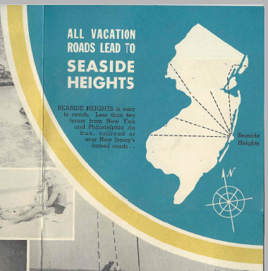

Official Seaside Heights OEM Message….
January 22, 2016OFFICIAL SEASIDE HEIGHTS OEM MESSAGE: The Seaside Heights Emergency Management team has been closely monitoring the approaching storm. The latest National Weather Service briefing out of the Mt. Holly office confirms that Seaside Heights can expect blizzard conditions through Sunday with snowfall up to 12” and moderate flooding. These conditions will no doubt impact our residents, especially those residing in historically flood prone areas on the west side of town along Bay Boulevard.
If you are elderly or have medical issues requiring special attention, please consider moving to upland areas west of the bridge until the storm passes. Although our first responders in the Police, Fire and EMS departments will be on duty, the conditions in town may cause delays or prevent them altogether from providing an immediate response.
If you elect not to voluntarily evacuate from Seaside Heights you should prepare for an extended period of immobility. Please maintain sufficient gasoline, food, medicine and potable water.
Motor vehicles must be removed from the streets whenever snow results in an accumulation of two or more inches and shall remain removed from the streets for 24 hours after the snow stops. When parking your motor vehicle in your driveway please make sure that no part of the vehicle blocks the sidewalk or curb. If your property does not have off-street parking we recommend that you move your motor vehicles to the parking lots located at Hiering Avenue & Ocean Terrace and opposite Breakwater Beach between Grant and Blaine Avenues. Any unoccupied vehicle parked in violation of these regulations may be deemed a nuisance and a menace to the safe and proper regulation of traffic, and any police officer may provide for the removal of such vehicle at the owner’s expense. – William Hibell, OEM Coordinator
Seaside Heights under BLIZZARD WARNING!
January 22, 2016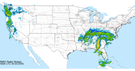
Snowfall rates in the 6-10 inch area, with winds topping 60 miles per hour. That qualifies as a blizzard in Seaside Heights. The National Weather Service has issued a Blizzard Warning for Ocean County. The snowfall could go up, if a small amount of rain and ice don’t keep numbers down.
… BLIZZARD WARNING REMAINS IN EFFECT FROM 7 PM THIS EVENING TO 10 AM EST SUNDAY…
* HAZARD TYPES… HEAVY SNOW AND STRONG WINDS.
* SNOW ACCUMULATIONS… 6 TO 12 INCHES, WITH THE HIGHEST AMOUNTS MOSTLY INLAND FROM THE COAST.
* TIMING… SNOW IS EXPECTED TO BEGIN LATER THIS EVENING. THE SNOW SHOULD MIX WITH AND THEN BRIEFLY CHANGE TO SLEET AND SOME RAIN FOR A TIME SATURDAY, THEN QUICKLY BACK OVER TO SNOW EARLY SATURDAY EVENING BEFORE TAPERING OFF EARLY SUNDAY MORNING.
* WINDS… NORTHEAST INCREASING LATE TONIGHT AND SATURDAY TO 30 TO 40 MPH WITH GUSTS UP TO 55 MPH.
* TEMPERATURES… MAINLY IN THE LOWER 30S.
* VISIBILITIES… REDUCED TO ONE QUARTER OF A MILE OR LESS AT TIMES.
* IMPACTS… AN INITIAL BURST OF SNOW LATER TONIGHT AND EARLY SATURDAY IN COMBINATION WITH STRONG WINDS CAN RESULT IN WHITEOUT CONDITIONS AT TIMES. HOWEVER, AS THE SNOW MIXES WITH SLEET AND RAIN FOR A TIME SATURDAY IT WILL MAKE IT VERY HEAVY AND WET. AS IT TURNS COLDER SATURDAY EVENING, SNOW SHOULD BECOME DRIER AND WHEN COMBINED WITH STRONG WINDS WILL RESULT IN WHITEOUT CONDITIONS AT TIMES. SHOVELING MAY BE PROBLEMATIC FOR THOSE WITH PHYSICAL AILMENTS. SNOW MAY CLING TO WIRES AND TREES WHICH COULD CAUSE POWER OUTAGES. ROADS COULD BECOME IMPASSABLE IN SOME AREAS DUE TO SNOWFALL RATES OF 1 TO AS MUCH AS 3 INCHES PER HOUR DURING THE HEIGHT OF THE STORM SATURDAY AND SATURDAY NIGHT.
PRECAUTIONARY/PREPAREDNESS ACTIONS…
A BLIZZARD WARNING MEANS SEVERE WINTER WEATHER CONDITIONS ARE EXPECTED OR OCCURRING. FALLING AND BLOWING SNOW WITH STRONG WINDS AND POOR VISIBILITIES ARE LIKELY. THIS WILL LEAD TO WHITEOUT CONDITIONS, MAKING TRAVEL EXTREMELY DANGEROUS. DO NOT TRAVEL. IF YOU MUST TRAVEL, HAVE A WINTER SURVIVAL KIT WITH YOU. IF YOU GET STRANDED, STAY WITH YOUR VEHICLE.
More Information
… A MAJOR WINTER STORM WILL AFFECT THE REGION TONIGHT INTO EARLY SUNDAY…
.STRENGTHENING LOW PRESSURE WILL TRACK TO OUR SOUTH AND EAST TONIGHT THROUGH LATE SATURDAY NIGHT, BRINGING SIGNIFICANT SNOWFALL AND STRONG WINDS TO MUCH OF OUR AREA.
The wind and coastal flooding threat has not diminshed.
… COASTAL FLOOD WARNING IN EFFECT FROM 4 AM SATURDAY TO NOON EST SUNDAY…
THE NATIONAL WEATHER SERVICE IN MOUNT HOLLY HAS ISSUED A COASTAL FLOOD WARNING. IT IS IN EFFECT FROM 400 AM SATURDAY UNTIL NOON SUNDAY.
* LOCATIONS… THE NEW JERSEY COUNTIES OF OCEAN, SOUTHEASTERN BURLINGTON, ATLANTIC, CAPE MAY AND CUMBERLAND. THE DELAWARE COUNTIES OF SUSSEX AND KENT.
* COASTAL FLOODING… WIDESPREAD MODERATE COASTAL FLOODING IS EXPECTED WITH LOCALIZED AREAS OF MAJOR COASTAL FLOODING POSSIBLE. THE COASTAL FLOODING WILL LAST FOR THREE CONSECUTIVE HIGH TIDE CYCLES AS WATER IS PUSHED UP AGAINST THE COAST AND INTO THE BACK BAYS AND ESTUARIES.
* TIMING… HIGH TIDE ON THE NEW JERSEY AND DELAWARE OCEANFRONT OCCURS BETWEEN 630 AM AND 730 AM SATURDAY MORNING, BETWEEN 700 PM AND 800 PM SATURDAY EVENING, AND BETWEEN 700 AM AND 800 AM SUNDAY MORNING. HIGH TIDE ON THE BACK BAYS AND ON DELAWARE BAY OCCURS LATER THAN THE HIGH TIDE ALONG THE OCEANFRONT.
* WAVES… WAVE HEIGHTS ON THE NEAR-SHORE WATERS OFF NEW JERSEY AND DELAWARE ARE FORECAST TO BUILD TO 15 TO 20 FEET OVER THE WEEKEND. WAVE HEIGHTS ON DELAWARE BAY MAY BUILD TO 4 TO 8 FEET.
* IMPACTS… NUMEROUS ROADWAYS WILL FLOOD AND MINOR TO MODERATE PROPERTY DAMAGE IS POSSIBLE. THE TIDES AND WAVE ACTION WILL LIKELY RESULT IN SIGNIFICANT BEACH EROSION.
PRECAUTIONARY/PREPAREDNESS ACTIONS…
THIS COASTAL FLOOD WARNING MEANS THAT MODERATE OR MAJOR TIDAL FLOODING IS IMMINENT. BE PREPARED FOR RISING WATER LEVELS AND TAKE APPROPRIATE ACTION TO PROTECT LIFE AND PROPERTY. FOLLOW THE RECOMMENDATIONS OF LOCAL EMERGENCY MANAGEMENT OFFICIALS.
DO NOT DRIVE YOUR VEHICLE THROUGH FLOOD WATERS. THE WATER MAY BE DEEPER THAN YOU THINK IT IS. YOU WILL BE PUTTING YOURSELF IN DANGER AND YOUR VEHICLE MAY BE DAMAGED, LEADING TO COSTLY REPAIRS.
More Information
… COASTAL FLOODING IS EXPECTED FOR THIS WEEKEND…
.STRENGTHENING LOW PRESSURE IS FORECAST TO PASS OFF THE NORTH CAROLINA COAST TONIGHT BEFORE MOVING NORTHEASTWARD AND OUT TO SEA OVER THE WEEKEND. THE STORM SYSTEM IS EXPECTED TO BRING STRONG ONSHORE WINDS TO THE COASTS OF DELAWARE AND NEW JERSEY FROM TONIGHT INTO SATURDAY NIGHT.
